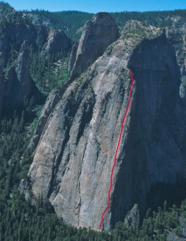
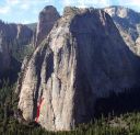
Direct North Buttress, Middle Cathedral 5.11 or 5.10 A0 |
||
Yosemite Valley, California USA | ||
| ||
|
Avg time to climb route: 12 hours
Approach time: 15 minutes Descent time: 1.5 hours Number of pitches: 19 Height of route: 2000' Overview
The Direct North Buttress of Middle Cathedral was one of the most difficult climbs in the world when it was freed in 1965, and it remains a burly testpiece. Steep chimneys that are very long, continuously difficult and poorly protected make the DNB a major undertaking. The DNB deserves its Grade V rating, and many parties are forced to bivy on the route or at the top prior to the extremely exposed Kat Walk descent.
Photos
- View all 9 photos of Direct North Buttress as: Thumbnails | Slideshow
Climber Beta on Direct North Buttress
Which SuperTopo guidebooks include a topo for Direct North Buttress?
Find other routes like
Direct North Buttress
History
One lazy Camp 4 afternoon in September 1961, Yvon Chouinard forced me into his car and drove down to El Cap Meadow without telling me what was up. This sort of thing had happened before, so I steeled myself for another rave. After we parked I was relieved when he looked south toward the Cathedral Rocks rather than north to El Cap, because I was terrified of the latter and only mildly scared of the more benevolent Cathedrals. “Look!” Chouinard exclaimed, pointing to the far right side of the wide northeast face of Middle. I wasn’t too good at picking out new lines, but I pretended to agree before confessing that I certainly couldn’t see what the hell he was talking about. “No route there, man,” I said (this being before the days of “no route there, dude.”).Of course a few days later we were up there, wandering between thin flakes and nubbly footholds, half the time unsure of where to go next. “No route here, man,” I often proclaimed, hoping Chouinard would believe me and we could retreat with honor. Actually, I was enjoying myself quite a lot, pounding pitons behind door-sized flakes, ignoring the monotone sound as the iron hilted way too easily (the classic sound of a well-driven piton, for those who have never driven one, is a rising pitch with each blow, almost orgiastic in tone). At one dicey spot in the early afternoon I popped an aid pin and a few below and tumbled 35 feet, my record at the time. We used lots of aid, too smart and too scared to head upward on possible 5.9 above poor placements. Yet we moved as smartly as coyotes on the hunt, and by dusk we had climbed 900 feet of brand-new terrain, complex and never easy. Relaxing onto big ledges, I unpacked my only bivy gear: a sweater and a down jacket. After a few munchies and philosophical discussions about the newest waitress in the coffee shop, we curled into fetal positions and actually went to sleep. Not for long, though. The rain was totally unexpected, and to our surprise it didn’t let up. Soaked and shivering by morning, we looked up at the prominent crack system above us. Our projected route had become a waterfall. Luckily, we were able to move left on roomy, connected ledges and, after a few easy pitches, reached the Kat Walk, a familiar descent route. Nine months later in June 1962, Chouinard and I were back at our high point by early afternoon, in perfect weather. About 400 feet higher we bivied. Then at midnight, rain struck once again, and we howled at the gods. By dawn this storm had become a mere drizzle, and we decided that up was better than down. The flared cracks that rose above us would have been hard in dry weather, but now they were slippery nightmares. As a master chimney expert, Chouinard led more than his share and did a superb job in the pitter-patter of rain. Much higher, as we passed abeam the previously named Thirsty Spire (what a misnomer now!), we knew the route was ours and gave it the unimaginative but accurate name: Direct North Buttress. By late afternoon we topped out and staggered back to the valley floor. Stalking the store for groceries, we weighed my down jacket on a scale. Seven and a half pounds! The route was soon repeated, and typical improvements came immediately. Better variations were jumped upon. The number of aid pitons went down as fast as the 1929 stock market, and the route was soon done in a day. Then came that inevitable moment that Chouinard and I knew would happen. In May 1965 the route, by this time known simply as the DNB, was free climbed. We had used probably 100 points of aid—many due to the wet rock on the second day—but better climbers came along. Frank Sacherer and Eric Beck, speedy as cheetahs, roared up the route in a mere 12 hours, rating six of the pitches 5.9 (some are now rated 10b). That Sacherer was wholeheartedly committed to a free ascent was reflected in Beck’s comment to me later: “On one pitch high up I was jamming a well-protected thin section and I called down to Frank, ‘I don’t know if I can do this.’ Among other things, I was getting tired. Frank immediately yelled up, ‘Don’t grab the pin.’” – Steve Roper Strategy
Start early, move fast, and be prepared if you are forced to bivy. Bring water and a lighter in case you must build a tiny fire for warmth in a bivy. Do not underestimate the cumulative effects of hot weather, draining leads, and the endless chimneying on the top half of the route.Pay attention to routefinding on the traverse of Pitch 6, the climbing on Pitches 7 and 8, and the corner transfer of Pitch 12. Be careful with the large loose blocks on Pitch 9; climb and set pro to the right and make sure your rope is not near the blocks that you must stand on for a few moves. Mid-summer temps and the sun’s position (directly in your face) make for unpleasant and potentially dangerously dehydrating conditions. However, the few long, cool days of mid-summer can be the perfect time to climb the DNB. During the early season there may be wet patches, especially near the top. In a storm, the upper 500 feet is a huge chimney system—or a huge raingutter. Regardless of your position, storm runoff from the slabs will soak the route. If you find yourself on top at dark or if you are tired or dehydrated, spend the night there rather than attempting the extremely exposed and somewhat inconspicuous 4th class Kat Walk, which has claimed climbers’ lives in the past. Retreat
Retreat is simple from the first five pitches and can even be done with a single 60m rope if you are careful. From higher on the route, retreat becomes problematic. From the top of Pitch 6 (slings around a large block) a double-rope rap to the right will gain the Pitch 5 bolted anchor. From the bolted anchor on the top of Pitch 7 you will most likely not be able to reach Pitch 6; however, from the slings on top of Pitch 8 (again around a large loose block) a double-rope rap will probably gain the Pitch 6 anchor. If stuck on top of Pitch 7, you may be able to rap down Paradise Lost (unknown anchor conditions). Above Pitch 8 you will need to leave gear except at a few trees (slings may be necessary). If for some reason you decide to retreat high on the route, consider bivying and finishing the following day, since retreat may be more dangerous.Approach
If driving from Camp 4: take Northside Drive to El Capitan Meadow. Turn left at the triangle and drive east until just before you meet Southside Drive (the one way road.) Park on the side of the road and walk 300 feet west on Southside drive to the pullout on the left (south). If driving into Yosemite Valley: on Southside Drive, park 300 feet before the turnoff to El Capitan Meadow on the paved pullout on the right.From the middle of the east most pullout, locate a trail and walk 300 feet, passing a climbers’ information sign, to the Valley Loop Trail. (Don’t start from the pullout to the west or all the following distances will be wrong.) From here, follow different trails depending on which route you are climbing: GET Yosemite Valley Free Climbs and read the rest this approach as well beta for over 200 other classic Yosemite routes. Descent
From the Kat Walk, follow a ledge trending slightly downward for 200–300 feet. When you reach a pillar (tree below it, ledges at base), work up the pillar to its top, then drop steeply down the other side through brush and small trees (careful!). About 100 feet after the pillar is the most dangerous section, a sloping ledge with no good holds (careful!). Another 200 feet around on the ledge, you will spot the trees, dirt and brush of the East Buttress walk-off about 150 feet below you. Continue contouring, then drop down 3rd class dirt until you gain the obvious East Buttress descent trail just before the campfire ring/large cairns (see descent below).Everything You Need to Know About
Yosemite Valley
Search the internet for beta on
Direct North Buttress
Links to related internet pages with info on Direct North Buttress
|
Other Routes on Middle Cathedral
|


