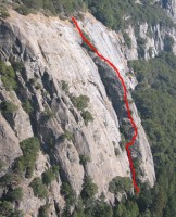
Regular Route, Sunnyside Bench 5.4 |
||
Yosemite Valley, California USA | ||
| ||
|
Google Maps Overview
|
|
|
The GPS coordinates for this route are shown below. See the GPS Marker Legend at right for details on each marker. Click on the Marker to see the actual GPS coordinates. Approach
From the Lower Yosemite Fall parking area, 0.3 miles east of Camp 4, walk north on the paved trail toward the fall. Cross the bridge at the base of the fall and continue east along the trail for 100 yards. Stop where the trail nears the rock wall. Move back left (west) along the base for 100 feet to the obvious large gully/corner.Descent
The descent takes about 30 minutes. From the summit, walk up for 250 feet until you meet a climbers’ trail. Traverse right (east) on the climbers’ trail for about 300 yards just above the steep slabs. Eventually the trail starts to peter out and it is possible to start working your way down to either an open talus field or a drainage. These lead to the Lower Yosemite Fall trail, which is followed back to the start of the route. |
Home | Climbing Areas | Free
Topos | Guidebooks | Route
Beta | Forum | Trip Reports |
Photos | Articles
Links | Terms | Privacy | FAQ | Contact
| About Us
Climbing Areas
Rock Climbing Yosemite |
Big Wall Rock Climbing Yosemite |
Rock Climbing Tuolumne |
Rock Climbing Sierra
Rock Climbing Red Rocks |
Rock Climbing Southwest |
Rock Climbing Zion |
Rock Climbing Tahoe |
Climbing Alaska
All trademarks property of their respective owners
How can we improve SuperTopo? Got feedback?
![]() Let us know!
Let us know!
Climbing is dangerous. Climb at your own risk.
