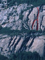
Selaginella, Five Open Books 5.8 |
||
Yosemite Valley, California USA | ||
| ||
|
Google Maps Overview
|
|
|
The GPS coordinates for this route are shown below. See the GPS Marker Legend at right for details on each marker. Click on the Marker to see the actual GPS coordinates. Approach
The recommended approach is to climb any lower route at the Five Open Books. As an alternate approach, follow the approach description above to the base of Munginella. From the fourth and last carabiner post, head west along the cliff to the streambed. Hike the streambed until you can climb slabs (4th class in early season when wet, 3rd class when dry). Move east (right) along the top of the slabs, following the well-traveled climbers’ trail east a few hundred yards to the base of the route. There are many similar-looking right-facing corners, so study the topo carefully. Don’t leave anything at the base or you will have to go out of your way on the descent to retrieve it. Descent
Walk the Yosemite Falls Trail for about one mile to Camp 4.
|
Home | Climbing Areas | Free
Topos | Guidebooks | Route
Beta | Forum | Trip Reports |
Photos | Articles
Links | Terms | Privacy | FAQ | Contact
| About Us
Climbing Areas
Rock Climbing Yosemite |
Big Wall Rock Climbing Yosemite |
Rock Climbing Tuolumne |
Rock Climbing Sierra
Rock Climbing Red Rocks |
Rock Climbing Southwest |
Rock Climbing Zion |
Rock Climbing Tahoe |
Climbing Alaska
All trademarks property of their respective owners
How can we improve SuperTopo? Got feedback?
![]() Let us know!
Let us know!
Climbing is dangerous. Climb at your own risk.
