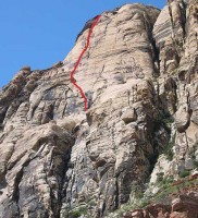
Solar Slab, Solar Slab Wall 5.6 |
||
Red Rocks, Nevada USA | ||
| ||
|
Google Maps Overview
|
|
|
A map of the general Red Rocks, Nevada USA area is shown below. No GPS coordinates for this specific route are available at this time. Approach
The approach is relatively flat and takes about 1-1.5 hours. Oak Creek Canyon is at the end of the loop road. You can also park at the old Oak Creek Campground or at an unnamed old road along the main highway and avoid the hassle of the Loop Road (an extra 20-30 minute hike in each direction).From the Oak Creek Trailhead (there is a bathroom here), follow the old roadbed up into the canyon. Here, the road winds gently down into the streambed, with a trail departing on the right about 100 yards after the road heads downhill. Do NOT take this trail—take the next one, about 50 yards further along. Hike up the canyon, passing some large boulders via a bit of scrambling past oak trees, then head up to the base of the Solar Slab area on a variety of well-worn trails. There are two main gully systems on this wall: the major one, extending from the top of the wall to the bottom; and the left-hand one, which goes up about 500 feet before ending below the huge white slab. Solar Slab Gully is the left-hand route, yet the upper part of the right-hand one is also called “Solar Slab Gully” and is an optional (not recommended) descent for the upper routes. Head for the smaller left-hand gully—all the routes begin within 100 yards of the bottom of this gully. Beulah’s Book and Johnny Vegas start to the left of the tree-filled Solar Slab Gully; Horndogger Select starts to the right. If you reach a point where the right wall meets the wash, you’ve gone about 300 yards too far. Descent
Rappel the upper routes with two ropes. Most of the lower routes either have no fixed rappel stations or lots of knobs to snag ropes, and so the recommended descent is to rappel Solar Slab Gully with a single rope, keeping the second rope coiled. This is because most of the raps are very short, and it allow you to climb back up to retrieve snagged ropes. A couple of the rap stations are in very exposed positions, and a belay is recommended for anyone uncomfortable reaching the bolts.It is also possible to do the longer Painted Bowl descent to get off these routes, and it is the only way to descend the upper tier routes with a single rope. See the descent description in the Black Orpheus descent section. Once at the base, reverse the approach to the car. With rappels, it takes most people 3-4 hours to descend from the top of the upper tier; from the top of the first tier routes, it takes about 2 hours. |
Home | Climbing Areas | Free
Topos | Guidebooks | Route
Beta | Forum | Trip Reports |
Photos | Articles
Links | Terms | Privacy | FAQ | Contact
| About Us
Climbing Areas
Rock Climbing Yosemite |
Big Wall Rock Climbing Yosemite |
Rock Climbing Tuolumne |
Rock Climbing Sierra
Rock Climbing Red Rocks |
Rock Climbing Southwest |
Rock Climbing Zion |
Rock Climbing Tahoe |
Climbing Alaska
All trademarks property of their respective owners
How can we improve SuperTopo? Got feedback?
![]() Let us know!
Let us know!
Climbing is dangerous. Climb at your own risk.
