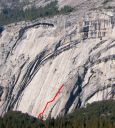
Royal Arches, Royal Arches Area 5.10b or 5.7 A0 |
||
Yosemite Valley, California USA | ||
| ||
|
Avg time to climb route: 7-10 hours
Approach time: 10 minutes Descent time: 2-3 hours Number of pitches: 16 Height of route: 1400' Overview
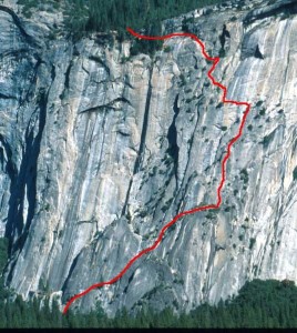
With more than 1600' of climbing, Royal Arches is the easiest long route in Yosemite Valley. Short, 5.6 moves are mixed in with long stretches of 3rd and 4th class circuitous climbing. The only hard section, a 5.10b traverse, is easily bypassed with a fixed pendulum. That said, Royal Arches is committing and has benighted more than a few climbers. The climbing varies from 3rd class walking on large ledges and 5.4 friction to 5.6 finger and hand cracks. The climb is well protected except for a few easy friction-climbing sections.
Photos
- View all 84 photos of Royal Arches as: Thumbnails | Slideshow
Climber Beta on Royal Arches
Which SuperTopo guidebooks include a topo for Royal Arches?
Find other routes like
Royal Arches
History
In 1936, with both Cathedral Spires climbed and the virgin Lost Arrow defining the impossible, the Valley pioneers reconsidered the walls. Pinnacles had real summits, places where no one had ever trod, yet there weren’t too many more lurking about. Some walls were out of the question, like El Cap and Sentinel. Others proved unattractive or had no obvious crack systems. An exception was the shining wall above the Ahwahnee Hotel, just left of the Royal Arches. If a few key features could be linked, a thrilling route might lead to the rim.The enormous, layered arches left of Washington Column spring directly out of the forest and curve upward until they fade out horizontally close to the rim. So prominent are these onionskin-like features that the Indians had several names for the formation. “Scho-ko-ni” referred to the arched shade of an infant’s cradle; and “hunto” meant an eye. Morgan Harris, a zoology junior at UC Berkeley, was obsessed by this area and lounged for hours near the recently-built hotel, studying the face with binoculars. He knew the main Royal Arches couldn’t be climbed—clearly, that was for a future generation. But just to the left lay lower-angled terrain, studded with trees, devoid of overhangs and blessed with cracks. One attempt in torrid weather failed, and Harris spent a week in a hospital recovering from sunstroke. After yet another attempt, Harris, Ken Adam, and Kenneth Davis succeeded on October 9, 1936. The climbing on the route was not especially tough, but the routefinding and rope techniques proved daunting. One new procedure, called by Harris a “swinging rope traverse,” overcame a blank section. (Later this technique became known as a “pendulum.”) Harris, wishing to cross a smooth slab in order to reach a narrow ledge some 20 feet to his left, climbed straight upward about 25 feet, placed a piton and had his belayer lower him from it. Then, held tight by the rope from above, Harris began running back and forth across the wall, straining to reach the narrow ledge and finally succeeding. Later, after yet another pendulum, the trio reached what they described as “an old tree-trunk,” a feature soon to become famous as the Rotten Log. This 25-foot-long, foot-thick dead log bridged a deep chasm, affording a unique method of reaching the other side. Harris had spotted this golden trunk from the Valley floor and hoped it would be strong enough to hold his weight. It was, although it vibrated crazily as he led across it. The three men reached the rim a few hours later, having completed the Valley’s longest route. The climb, often the first serious one that beginners mastered, became immensely popular during the 1950s and 1960s. Hundreds of climbers endured their first bivouac at the top of the route or on the descent, for the climb was a long one—16 pitches with short ropes. Those who started late, or who hadn’t yet dealt with multi-pitch routes, had campfire stories to tell forever. The Rotten Log was the chief attraction of the route, and many thousands shuffled with trepidation across this tilted, shaky pole. It finally parted company with the rock in the spring of 1984. Pieces of the “True Log,” soon scooped up from far below by Dr. Gus Benner, ended up on various Berkeley shelves as relics. A moderate but undistinguished alternate to the Log surfaced immediately, but never again would the route have the same cachet. – Steve Roper Strategy
Expect crowds on the climb and start early. Water pours down much of the route in winter and early spring (Tip: when Pitch 10 is wet, it’s easier to climb barefoot). If climbing during this period, be prepared to improvise a route around wet sections. Some parties spend an entire day or more on this climb. Others have done the route in less than an hour, car to car. Be prepared to pass parties or to be passed at the intermediate belay stations, or by using the variations noted in the topo. If you arrive and find a massive queue on the first pitch, consider the other two starting variations. It is easy to pass parties until Pitch 5; above this there are few opportunities to pass. The last pitch, a friction traverse above a 1400-foot drop-off, is the psychological crux of the route. Regardless of how you do this pitch, the follower is looking at the same long pendulum fall as the leader. The lower option is easier, and a bolt protects the scary traverse across a blank slab. Keep all your weight on your feet, stand up straight (don’t lean forward), and make small steps. Another option: if you’re scared or in bad weather, clip the old bolt and simply lower off into the dirt/pine needles below. The follower can leave a biner on the bolt and lower off to the dirt, then hike up, clip into a tree, and untie fully. Then the leader can pull the rope through the leaver biner and toss it back down to the follower. If night falls as you finish the last pitch, it is possible to bivy in the trees or above on the rim. Retreat
Rappel the route with two 50m or 60m ropes. Retreating from below Pitch 15 requires leaving gear at some stations.Approach
From the northeast corner of the Ahwahnee parking lot, take the hikers’ trail east. After 120 yards and 50 feet after a stream crossing (may be dry in summer and fall), locate a climbers’ trail on the left. Follow this for 150 feet to a large left-facing corner and the start of the route. For Arête Butler and the alternate Royal Arches starts, skirt the base to the east (right).Descent: 3 Options
1) Royal Arches Rappel RouteThis is the recommended descent (see Royal Arches Rappel Route topo). It requires two 50m ropes or one 60m rope and starts from Pitch 15 of the Royal Arches route. This descent takes 2-3 hours. 2) North Dome Trail to Yosemite Falls Trail This 8.5 mile descent takes 4-6 hours, requires strenuous cross-country hiking, but has little exposure and no rappels. From the top of Royal Arches, walk north for about 1 mile (no clear trail) and pick up the North Dome trail. Walk west for about 4 miles to the Yosemite Falls Trail. Walk 3.6 miles down to Camp 4. 3) North Dome Gully If you have North Dome Gully wired, it’s the fastest descent from Royal Arches. It takes about 2 hours if you’re familiar with the descent, but can take 4 hours if it’s your first time and you get off route. See the North Dome Gully Descent description for more information. If not familiar with North Dome Gully, then use the Royal Arches Rappel Route. Everything You Need to Know About
Yosemite Valley
Search the internet for beta on
Royal Arches
Links to related internet pages with info on Royal Arches
Other guidebooks that include info on Royal Arches
|
Other Routes on Royal Arches Area
|


