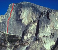
Regular Northwest Face, Half Dome 5.12 or 5.9 C1 |
||
Yosemite Valley, California USA | ||
| ||
|
Google Maps Overview
|
|
|
The GPS coordinates for this route are shown below. See the GPS Marker Legend at right for details on each marker. Click on the Marker to see the actual GPS coordinates. Approach
There are two approaches: The John Muir Trail and The Slabs. Hiking the John Muir Trail from Happy Isles to the eastern shoulder of Half Dome (7.5 miles) and then following a climbers' trail to the base (0.5 miles) is the straightforward but grueling option. The Slabs, although technically more difficult, is much faster and can mean the difference between being first in line for the Northwest Face or fifth.The Slabs
This 2.5 mile approach takes 2-3 hours and gains 3,000 feet in elevation. About 1.1 miles are on hikers’ trail and 1.4 miles are on climbers’ trail that involve exposed terrain, fixed ropes, and occasional 4th class.Park at Curry Village. Take the shuttle bus to the Mirror Lake turnoff. Walk on the road for a few hundred yards to Tenaya Bridge, gain the trail east along the south shore of Tenaya Creek to Mirror Lake. From the west end of Mirror Lake (marked by a small spillway) continue a few hundred yards until you reach a dip in the trail followed by a large rotting log. Wander (you may or may not find the climbers’ trail) up the hill for another .25 miles until you hit the base of The Slabs. Work your way upward along the base of slabs until you reach a high point where a faint trail leads up, slightly to the right to an 80' 4th-class section through some trees. Continue right and then left for another 150' until you reach another slab and the first fixed ropes. From the top of the fixed ropes, continue up for 60' and then cut left across a narrow 150' catwalk that leads to the base of a boulder-strewn drainage. Move up the drainage to a point about 20' before the base of a slab, then head left up a 3rd-class section. A sandy trail at the top of the 3rd-class leads to the base of a large slab and then heads left to a large drainage. Cross the drainage gully and follow a faint trail that leads left and then cuts back right to the drainage. Follow the left edge of the drainage until you can cross right on a series of narrow 4" ledges above an exposed slab. Follow the right side of the drainage for 300' until you reach the base of a slab, and then cross left to the uppermost left side of the drainage to a steep fixed rope. If no fixed rope, negotiate the next slab by walking left along a ledge, and then cutting back right and up towards the east edge of the drainage. A faint trail leads up through bushes and to the right, back into the drainage and to the base of the next fixed ropes. After climbing the two steep, fixed ropes remain in the drainage for another 80', then exit right and join a trail about 20' from the edge of the drainage. Follow the trail up through a 30’ steep bushy section and gradually left back across the mouth of the drainage and up towards the base of the wall. For Tis-sa-ack and all routes starting to the east, just before reaching the base, gain a faint trail that heads left and follows the base of the rock buttress through bushes, eventually ending at the base of the wall. Descending the Slabs approach
Either descend the way you approached or, before entering the gully for the first fixed rope, continue down the trail until reaching the edge of a cliff above the drainage and a tree with rap slings. A 50m rap brings you back to the regular approach/descent route.Descent
The nine-mile hikers trail offers the best descent from the summit. |
Home | Climbing Areas | Free
Topos | Guidebooks | Route
Beta | Forum | Trip Reports |
Photos | Articles
Links | Terms | Privacy | FAQ | Contact
| About Us
Climbing Areas
Rock Climbing Yosemite |
Big Wall Rock Climbing Yosemite |
Rock Climbing Tuolumne |
Rock Climbing Sierra
Rock Climbing Red Rocks |
Rock Climbing Southwest |
Rock Climbing Zion |
Rock Climbing Tahoe |
Climbing Alaska
All trademarks property of their respective owners
How can we improve SuperTopo? Got feedback?
![]() Let us know!
Let us know!
Climbing is dangerous. Climb at your own risk.
